
 |
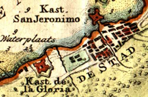
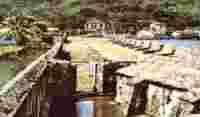
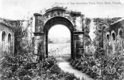
Castillo San Gerónimo (1500 - 1739)
|
||||||
|
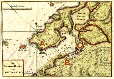
1750 Map of Panama Showing San Lorenzo, Nombre de Diós & Porto Bello |
||||||
|
Rodrigo de Bastidas, was a leader of an expedition of exploration, that set sail from Spain in October, 1500, in two ships. Vasco Nuñez de Balboa and Juan de la Cosa, were members of the expedition. They reached what is now know has Venezuela, and continued sailing west along it coast. They sailed past el Cabo de Vela, and reaching el Golfo de Darien, explored it, and the Atrato River. They continued north, along the coast as far as El Retrete, possibly as far as the site were Nombre de Diós, would be founded years later, and even as far as the future site of Porto Bello. Bastidas did not name these two, sites, and it would be up to others, to name them. Because of this, Bastidas has been given the credit for the discovery of Panamá. Christopher Columbus sailed on his fourth and last voyage of exploration, from Cadiz on May 11, 1502. With him on this voyage was Bartolomé Columbus, his brother, and his second son, Fernando. Stopping off in Española, he had the opportunity to confer with Bastidas, and examine his charts. He sailed west, past Cuba, and landed on the northern coast of Honduras, east of the Yucatan. Skirting the coast of Tierra Firme, he sailed east over the Honduras hump and then south east. He continued skirting the coast of Central America, past Honduras, Nicaragua and Costa Rica. On October 6, 1502, they entered Almirante Bay, in what is now known as Panamá. Columbus continued along the coast, eastward, past Chiriqui and Veraguas, past the Chagres River, and the Bay of Limon, until he reached a beautiful bay, that he named Puerto Bello on November 2nd, 1502. They were forced to stay there 7 days, due to inclement weather. By November 24, he had reached the most eastward he would travel on the coast of Panama, at a harbor, that he named El Retrete. The next person to enter Puerto Bello, was Diego de Nicuesa, the appointed governor of Castilla del Oro. He had the benefits of both Bastides and Columbus' charts, and was headed to Veraguas, where Columbus had discovered much gold. He had sailed west to the Almirante Bay, and then turned east, in search of Veraguas, and his new lands. They entered the harbor of Puerto Bello, and some of his men were killed by the natives. Nicuesa was given the distinction by the Spanish as the discoverer of "Puerto Bello", what he officially named it, since he actually entered the harbor and explored the area in 1509. Fearful of the belligerent natives in the area, he continued east, searching for a friendly place to settle, and establish his capital. He eventually arrived in a harbor, where the land appeared fertile, and the coast was building a fort, and Nicuesa ordered, "Paremos aquí, en el nombre de Diós". Here they founded the town of Nombre de Diós, the first permanent Spanish settlement in Tierra Firme. From here, Nicuesa sailed to Nuestra Señora de Antigua del Darien, to oust Balboa, but was ousted himself, and on March 1, 1511, he was set adrift in a leaky boat, and was never heard from again. At this point, all of the settlers at Nombre de Diós, accepted Balboa's offer, to relocate to Antigua, and the settlement of Nombre de Diós, was abandoned. Diego de Albites, a captain who had accompanied Pedrarias from Spain to Tierra Firme, helped establish Panamá in 1517. With permission from Pedrarias, to colonize Veraguas, he sailed form Antigua in 1518. He never reached Veraguas, but he attempted to establish a settlement at Puerto Bello in 1518. In 1519 moved and refounded the settlement that Nicuesa abandoned, Nombre de Diós. This settlement remained as the northern terminus of the trans-isthmian trade. Panama and Nombre de Diós are opposite each other, and gradually, a paved road (El Camino Real) was built connecting both settlement. When the gold from Peru, was shipped to Spain, it was shipped to Panama, on the Pacific, and crossed the isthmus on El Camino Real, to Nombre de Diós, and then shipped to Spain yearly on the Treasure Fleet. The history of Tierra Firme, was controlled by these two settlements for the next 60 years. |
||||||
|
1700 Map of Darien, Panamá, showing Porto Bello This map appeared in Le Neptune Francois, Vol. 2, No. 28, Amsterdam 1700 by Pierre Mortier. This map shows the Bay of Porto Bello, on the North Sea (Caribbean Sea)
1768 Map of Porto Bello by Issak Tirion appearing in the Nieuwe en Beknopte Hand-Atlas published in Amsterdam.
|
||||||
|
On July 29, 1572, Francis Drake, captured the town of Nombre de Diós. He attacked the town, with a force of 73 men, in three pinnaces and a shallop. After a bloody battle, he was able to defeat the defenders. Shortly there after, reinforcements arrived from Panamá, Drake was wounded, and they had to retreat, without much loot. The left behind silver bars, valued at a million pounds sterling, and other treasures. In their fighting, they reached the doors of the Kings Treasure House, but were not able to enter it, before the Spaniards counter attacked. On April 1, 1573, Drake attacked Nombre de Diós again, this time capturing a mule train, loaded with treasure, outside of Nombre de Diós. This time, they took every thing they could carry. In August, 1595, with a fleet of 26 ships, Drake set out to Panama again, hoping to take Nombre de Diós and the city of Panama. Crossing the isthmus on the Camino Real, his forces were stopped, by well prepared Spaniards. When they got back to Nombre de Diós, they proceeded to burn the city, and then sailed to Puerto Bello. Drake got sick on the way, and died. On January 29, 1596, he was buried at sea in the harbor.
|
||||||
|
|
||||||
|
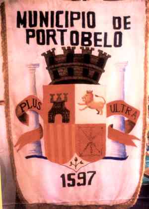
In 1586, the Italian engineer, Juan Bautista Antonelli, was sent by the King of Spain, to examine the different ports in the Caribbean, and make suggestions on how to improve them. Antonelli already had the distinction of having designed several of the major fortresses in the Spanish Indies. At the time, Nombre de Diós was the site where all ships were loaded with treasures for the return to Spain, and Puerto Bello was a small town of only 10 houses. After noting the excellent port facilities and defensible terrain, he wrote to King Felipe of his findings. "If it might please your Majesty, it would be a good idea that the city of Nombre de Diós be brought and built in this harbor". The king ordered the move, and San Felipe de Puertovelo was founded on March 20, 1597 by Don Francisco de Valverde y Mercado. He was a factor of New Spain (Mexico) and a comisario. The residents of Nombre de Diós were moved to the new town site (a distance of about 5 leagues). Puertovelo was granted the title of city by orders of Valladolid granted to Nombre de Diós November 23, of 1537. The coat of arms granted to Nombre de Diós on December 7, 1537, was also transferred to Puertovelo. The coat-of-arms was a castle and ship, bordered with the inscription "Tierra Firme, Breñas de oro" At the same time as the fortress were being built, construction began at the mouth of the Chagre River for another massive fort. In the village of Cruces, smaller forts were built for its defenses along with royal warehouses and buildings, constructed of stone. The settlement was arranged in the form of a half moon, with the two points, aiming East and West. The bulk of the town was located in the center of the crescent. From the Plaza de la Mar, there were two street, going to the Castillo Santiago. From the Plaza de la Mar, another road continued towards the mountains. First it had to cross a small bridge over a creek (descending from the mountains), and then to another plaza. (the two plazas were about 100 paces apart). There were a lot of cross streets, and the entire community was paced off at 500 paces in each direction. In the town, there were about 50 houses, a cathedral, the Convent of Mercy, a hospital, and the Kings houses on the Plaza de la Mar. The City Government houses, (El Cabildo), were located on the second plaza. Most of the homes were constructed of wood, with stone footers. Some were two-stories, many windows, and tile roofs. There were also some government warehouses. Some of the houses were built of stone and brick, that being the preferred building material, since they thought that they were healthier and wood buildings. Puertobelo was made up of four suburbs, Triana (where the poor Spaniards, and the Kings slaves lived), Merceds (where the well to do citizens lived), Guinea (residence of the free Negros), and the shanty town. There were some fine houses in the better suburbs, with gardens and plantations. The shanty town, contained about 30 or 40 houses built of cane and straw. The outskirts of town were covered with jungles, and required great effort to keep it under control. The town made its income from brokers, which paid the city a yearly stipend of 2,000 ducats, 2 reales for every head of cattle killed, 2 pesos for every Negro brought to town (this amounted to about 1,500 pesos a year). It biggest expenditure was that of keeping the jungle from overtaking the town, and repairs to the highway to Panamá. |


 |
Puertobelo was located 80 leagues, west of Cartagena and 12 leagues to the mouth of the Chagre River. Its domain extended 50 leagues east, to the country of the hostile Indians in Uraba, 9 leagues to Panamá, and to the west, it extended as far as Cocle. Most of its domain in the south was not inhabited by Spaniards, except for an occasional hacienda, on the road to Panamá. There were some small towns, populated by the natives, and some hidden villages that belonged to the Cimarron's. The weather in Puertobelo was very bad. Located in the tropics, it rain just about every day. From January to April, (the Dry Season) the weather was dryer and healthier.
The Portovelo River emptied into the bay, about 1,000 paces from town. The river was small, and could only be ascended about 1 league by Indian dugout. There was another river, the Dominica, that emptied into the bay. Along the coastline, there were another 24 rivers, that emptied into the sea. The only navigable river was the Chagre, that could be ascended by boat during the winter, getting you within 6 leagues of Panamá.
The Spanish, considered Porto Bello to have the finest harbor in the Americas. "El puerto es el mejor, mas limpio, capaz y seguro de todas las Indias", from a quote by a Spaniard in 1607. It contained an anchorage of approximately 3 kilometers, extending east to west. The entrance to the harbor, had a passage way of between 1.5 to 1.8 kilometers. The depth at the entrance was 17 fathoms and next to the town, it was 7.5. The harbor was large enough to contain 300 galleons and 1,000 smaller ships, with another 2,000 ships, outside the protection of the forts.
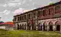
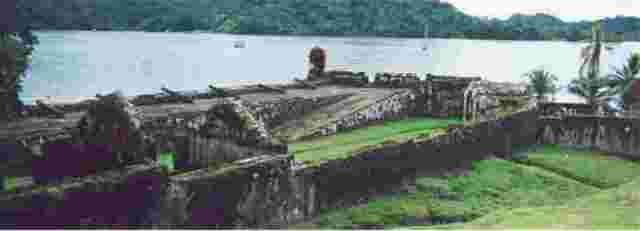
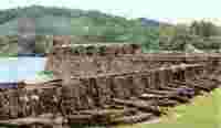
Puertobelo was well defended, by some natural defenses and a series of fortresses, constructed by the Spaniards. El Castillo de San Felipe de Todo Fierro, (the word Fierro means Iron, and is the reason that it is named the Iron Castle on some old maps), was the main defense at the entrance to the harbor. It was located at the base of a large hill, which made up the projection of land on the north side of the harbor. The forts were constructed of coral rock, that was mined underwater, from the reefs all along the coast. The castle walls were about 3 meters thick. While still wet, this rock was very easy to work with, and once dried, it became very strong. It worked like the coquina used in Florida that had the ability to absorbed a cannon ball, without cracking and causing much damage, or exploding. The cannon shots, just put a dent into the surface of the stone. To bind these blocks of stone, the Spaniards used a mixture of red clay with lime, which when hardened, was just as strong as the stone itself. (This stone worked so well, that in 1739, when Admiral Vernon captured Porto Bello, he tried to demolish the fortifications. He claimed that it took him about 18 days to blow them up due to the difficulty of getting explosives into the stone.)
![]()
The ravages of the buccaneers on the Spanish Tierra Firme, proved to the Spanish government that the protection it was providing for Panama, was not working. By 1580, they had three Men-of-Wars stationed of the coast of the isthmus as protection from pirates. In 1591, a larger fleet was sent to defend the coast. Land defenses became essential, and Cruces and other points along the Camino Real were fortified. In 1595, the Castillo de San Lorenzo was erected at the mouth of the Chagres River. The defenses of Puerto Bello were also enhanced.
When the Royal Treasure House was moved from Nombre de Diós to Porto Bello, in 1597, engineers were sent from Spain, to build the defensive works of Porto Bello. A very stout fortress was built to protect the entrance to the harbor. San Felipe was equipped with 35 great cannons, and a garrison of 50 soldiers. On the other side of the harbor, a smaller fort, named Santiago, was built. Santiago had 5 cannons, and a garrison of 30 soldiers. In Triana, an eastern suburb of the city, another fortified castle, San Geronimo, was built. Smaller garrisons were built, all around the city, and controlled all approaches to the city. The King's Treasure House, was solidly built and fortified, and troops were stationed around it, for protection. Porto Bello had a total of 300 soldiers garrison there during the times of the annual fair
.
 |
|
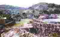
Photo curtsey of Ruben Arcia |
In the early morning of February 7, 1602, Captain William Parker, with 150 men and 2 ships, entered the bay and were challenged by the sentries at Castillo San Felipe. He convinced the sentries that they were a Spanish ship from Cartagena, and was passed through and instructed where to drop anchor and wait for daylight. When the sentries became distracted, his men slipped into small boats and landed at Triana, a suburb of Porto Bello. He set Triana on fire, and then marched onto Porto Bello. After a battle, he was able to capture the governor and the garrison. In the Royal Treasure House, they found over 10,000 ducates, and other booty in the city. He did not attempt to capture the larger forts at the entrance of the harbor. He escaped on two Spanish ships he captured, and sailed past the forts at the entrance of the bay. As he approached San Felipe and Santiago, the open fire and he returning their fire. They fired over 30 cannon shots at him, but all missed their mark, and they were able to slip out to sea, with only one casualty, Captain Parker, who was wounded by musket fire.
The next attack on Porto Bello, was by Henry Morgan, in June, 1668. He appeared with a force of 9 ships and 460 fighting men. They first took the castle of Triana, and blew it up with its defenders. He then advanced on the town, and after some heavy fighting, took it by the next day. They tortured the residents, and plundered all they could find. A force of 1,500 men were sent from Panama to the rescue, but they were routed. Morgan stayed in Porto Bello for about two weeks. Before he left, he burned the town, destroyed the forts and what cannons he did not take, he spiked, so they could never be used again. The booty was valued at 260,000 pesos, besides large quantities of silk, linen, cloth and other merchandise.
In 1679, Porto Bello, again fell prey to pirates, who took all they could find (several thousand pesos of booty). The pirates then planed to take Panama City. Under the command of Captain Bartholomew Sharp, Captain Coxon, Captain Sawkins, Captain William Dampier, Captain Lionel Wafer and a large group of native allies under the command of the cacique Andrés from the Darien. They were never able to take the city of Panama, but they roamed all around the country, plundering and sacking every town and village, they could find up and down the Pacific coast of Central and South America.
The last time Porto Bello was overrun, was on November 21, 1739. Admiral Edward Vernon, with a force of 6 ships, 2,735 men, 370 cannons entered the harbor. During the day, a battle was fought between the English ships and the Spanish forts. After a continuous bombardment, the city and fortifications, surrendered to the English. The inhabitants were not molested and the town was not pillaged. The pay for the defenders of the fort, was captured (10,000 pesos) and was distributed among the English troops and sailors. Vernon took all of the cannons he could and then spiked the rest, and destroyed the fortifications, before leaving.
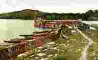
Castillo San Gerónimo
 |
 |
 |
 |
 |
 |
| Panama History | Home |